20 Aralık 2012 Perşembe

Lewis and Clarke's Big Mistake?

To contact us Click HERE
In December 1805, after making the first transcontinental land crossing by white man, Lewis and Clark decided to overwinter at a location south of present day Astoria (see letter A on map).

They called their collection of log buildings, Fort Clatsop, and remained there until late March 1806 (see artist rendering).

Unfortunately, they learned rapidly that they had picked one of wettest, dampest lowland places in North America, with plenty of wind to make things even more unpleasant  They were miserable, as their comments on December 16, 1805 made clear: 
 "The rain continues, with Tremendious gusts of wind. The winds violent.   Trees falling in every direction, whorl winds, with gusts of rain.    Hail & Thunder, This kind of weather lasted all day, Certainly one of the worst days that ever was!" 
Frequent comments included: "we are all wet and disagreeable," "cold and a dreadful day," and, "the rain continued as usual" 
If only they had a meteorologist with them!  Consider the Oregon annual rainfall map (see image).  They had camped in a location that receives about 100 inches a year, most of it falling during the midwinter period in which they camped.  Not a good choice.  If only they had made camp near Portland, they could have found a location with roughly a third as much rain, and considerably less wind.  Of the 106 days the Corps of Discovery spent on the coast only twelve were free of rain and only six were sunny.   I suspect they knew they had picked a very wet location, but wanted to be near the ocean where they would have a chance to interact with a passing ship.  Perhaps they hoped for a ride to Hawaii.
And one more thing:  only a few miles from Fort Clatsop there is Cape Disappointment, the foggiest location in the lower 48 states, with 106 days of heavy fog a year.  So they were wet, fogged in, and we haven't have talked about the strong winter winds of the area.  Not your winter vacation spot.
Typical (foggy) conditions at Cape Disappointment


Storm Update

To contact us Click HERE
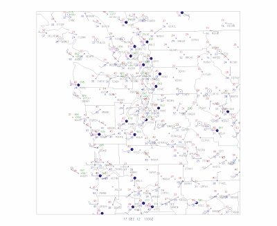
Just a brief update.  The storm pretty much followed yesterday's model prediction.  The low center is now over the north Cascades and moving inland rapidly.  Here is the latest surface chart over western WA at 5 AM.  Strong winds have followed the low into the southern and central Sound, with winds gusting to 40-50 mph.  Also strong winds have pushed into the Strait.  We are just past the max winds in Puget Sound, with weakening to occur this morning.
The maximum winds (gusts) for the 24 h ending 5 AM for Washington and Oregon are shown below.  The Oregon coast got hammered with lots of places getting 50-60 mph winds, some more.  Some 40-50 mph gusts in the Willamette valley.

 For Washington, 60 mph+ along the coast, with 40-60 mph in the Strait.  40-50 mph gusts in southern Puget Sound, with higher winds (up to around 60 mph) in the southern Sound.

The biggest storm of the season so far (and I haven't even talked about snow in the mountains), but typical of the strongest storm we get each year.

Now Lowland Snow Showers

To contact us Click HERE
Cold air has moved in behind the low pressure center;  in fact, the atmosphere is now cold enough that snow can reach the surface in heavy convective showers.

The latest visible satellite picture shows lots of convection in the cold unstable air approaching the region.
 We now have strong onshore flow of  cool, shower-filled air with marginal temperatures for snow.   The snow level is now around 1000 ft, but heavy showers can lower the snow level by melting and evaporation.  Snow showers have already begun around the region

The flow is generally westerly, which means heavy snow in the Cascades.  But there where will be some locations like Seattle, that will be in the rainshadow (snow shadow!) of the Olympics.

Here is the UW WRF model snow forecast for the 24 hr ending 5 AM Tuesday.  Some snow reaching the surface over the lowlands, but not much.  Lots in the Cascades.

 What if the model is wrong about how much snow reaches the surface?  Lets look at how much total precipitation the model is forecasting over that 24-h period.  You can see the rainshadow around Seattle.

So bottom line:  don't be surprised if there are few snow showers....even some light accumulations away from the water and on hills....particularly away from the lee of the Olympics (e.g., Seattle).

The threat of lowland snow doesn't end tomorrow AM, here is the predictions for the next 24h:


Record Water Levels in Seattle: Why Did It Occur and Is Global Warming Important?

To contact us Click HERE
On Monday morning, during a modest windstorm, the Seattle tidal station (NOAA gauge 9447130) measured the highest water level since measurements there began in 1901.  The results was beach flooding and damage to docks, beachfront homes, and other coastal facilities (see pictures below).  Now we didn't beat the old record by much.   Water reached 14.51 feet and the mean low water mark exceeded the previous record, 14.49 feet, set in January 1983, by .02 feet.   Well, a record is a record, even if you win by a whisker!  
West Seattle During the Storm (courtesy W. Seattle Blog)
Alki Beach (courtesy W. Seattle Blog)
Submerged fishing dock in Mukilteo (courtesy Bob Donegan, Ivars, Inc)
 The media, such as the Seattle Times, had some big headlines on this new record, and some of them suggested that either global warming had a hand in this, or the high tide was a warning of things to come:  "Yesterday's tide would be an everyday tide by midcentury."


So what is the truth about this sea-level record?  Why did the record occur on Monday?  Some of the answers might surprise, perhaps. 

The high water on Monday had a number of contributing factors.

First, we started with astronomically very high tides, sometimes called "King Tides",  that occur during midwinter.   Tides are mainly caused by the gravitational attraction of the moon, but the sun also contributes.  The highest tides tend to occur when the sun and moon are lined up, which happens during a full moon, and when the moon is closest to the earth (perigee).   During our midwinter, the sun is closest to the earth (discussed in an earlier blog), and thus its gravitational attraction is stronger.  The result, the highest "King" tides.  Nothing to do with a certainly local TV station.
Centered on January 2, the earth is closest to the Sun, enhancing the tides.
 The following figure shows you the predicted tides, what actually happened, and the difference on Monday (12/17), Tuesday, and part of Wednesday (time in GMT).  Our big observed tide occurred around 1600 GMT (8 AM) Monday.  The predictions were too low.  Why?  The big reason is that we had a strong low pressure area over us (the storm) and low pressure caused sea level to rise.

Low atmospheric pressure results in a higher sea level. This is known as the "inverse barometer effect", with water level rising about 1 cm for every 1 mb (1 hPa) drop in pressure.  Here is the pressure at Seattle during the period.  The pressure had dropped to 


around 980 mb, with the lowest pressure around 0900 GMT (roughly 1 AM),  hours before the astronomical high tide.  If average pressure is about 1013 mb, the pressure dropped to about 33 mb below normal, which would bring the water level up by about 33 cm or about 1.1 feet.  This is one reason why the difference between actual and predicted was largest in the early morning hours.  

Another factor that brings up sea level is the storm surge effect, the influence of strong winds pushing water up on the beach.  At Sea Tac Airport, the winds switched from southerly (roughly parallel to the shore) to SW (more of an onshore component) around 2-3 AM, and the winds increased rapidly during the early morning hours (see graphics).
The implication is that we were lucky:  the storm hit too early to maximize the water level.  It if had hit 4-6 hrs later, the tides might have been a half a foot or so higher.  Then we would have really had a record!

We have King tides every year, but how often do we get 980 hPa lows like Monday's storms?  Well, lets check the UW records back to 1996.  Here is a plot of sea level pressure from Sea Tac for the period.   Looks like we get that low approximately every other year.  
So to be in record territory we need to get a King Tide, which is limited to midwinter, and get a major storm phasing in with relatively close timing.   Plus you need a significant onshore component to the wind to push water up on the beach. You can see why it is hard to break records.  Talking to some of my colleagues, we really had the feeling that this storm had unusually strong onshore flow (more of westerly component to the wind) along the eastern shore of Puget Sound.  This map illustrates:
It all came together for this storm.

What about sea level rise?  How did it contribute?

 Here is the sea level rise over the past century at Seattle.  An upward trend of about 8.1 inches over the last century.  But if you look closely and ignore the trend line, you will see there really little trend during the past 30 years.  Much of the trend in sea level rise began before humans could have had a large impact on sea level by increasing greenhouse gases (human influence becomes significant around 1970).  So both natural and anthropogenic (human-induced) warming has contributed to sea level rise in Seattle.  Sea level rise is making such records easier to break, but it is important to keep in mind that local sea level has not changed since the time of the previous record (1983). 
Interestingly, the eastern Pacific is a region where sea level has not been rising recently.  To illustrate this, check out a figure from the IPCC (2007) report (IPCC is collection of international scientists working on the global warming issue). This graphic shows change in sea level from 1985-2010 from satellite data.  In our area, general sea level has remained the same or fallen!  
 In the long term, the earth will warm profoundly from increases in greenhouse gases such as CO2 and that will surely cause substantial increases in sea level everywhere.  But we must be careful in pointing the finger at human-caused global warming for extreme weather events today, such as the high tides in Seattle during our Monday storm.

16 Aralık 2012 Pazar

Lewis and Clarke's Big Mistake?

To contact us Click HERE
In December 1805, after making the first transcontinental land crossing by white man, Lewis and Clark decided to overwinter at a location south of present day Astoria (see letter A on map).

They called their collection of log buildings, Fort Clatsop, and remained there until late March 1806 (see artist rendering).

Unfortunately, they learned rapidly that they had picked one of wettest, dampest lowland places in North America, with plenty of wind to make things even more unpleasant  They were miserable, as their comments on December 16, 1805 made clear: 
 "The rain continues, with Tremendious gusts of wind. The winds violent.   Trees falling in every direction, whorl winds, with gusts of rain.    Hail & Thunder, This kind of weather lasted all day, Certainly one of the worst days that ever was!" 
Frequent comments included: "we are all wet and disagreeable," "cold and a dreadful day," and, "the rain continued as usual" 
If only they had a meteorologist with them!  Consider the Oregon annual rainfall map (see image).  They had camped in a location that receives about 100 inches a year, most of it falling during the midwinter period in which they camped.  Not a good choice.  If only they had made camp near Portland, they could have found a location with roughly a third as much rain, and considerably less wind.  Of the 106 days the Corps of Discovery spent on the coast only twelve were free of rain and only six were sunny.   I suspect they knew they had picked a very wet location, but wanted to be near the ocean where they would have a chance to interact with a passing ship.  Perhaps they hoped for a ride to Hawaii.
And one more thing:  only a few miles from Fort Clatsop there is Cape Disappointment, the foggiest location in the lower 48 states, with 106 days of heavy fog a year.  So they were wet, fogged in, and we haven't have talked about the strong winter winds of the area.  Not your winter vacation spot.
Typical (foggy) conditions at Cape Disappointment


Major Wind Event on Monday?

To contact us Click HERE
 Saturday afternoon update:  the latest runs are pushing the strongest gradients southward, which would lessen the strength of the storm from Olympia northward...more after the next runs....cliff

I waited to mention this issue on the blog, but it is now looking like we will have a significant wind event over the coast and western Washington on Monday, particularly during the morning.

The cause?  A fairly deep low pressure system that is forecast to move across NW Washington and southern BC.

The models were all over the place yesterday, but today the European model, generally the most skillful, and the American GFS model are pretty much on the same page;  this gives us more confidence in the forecast.

Although powerful, this system is NOT in the same class as the Inauguration Day Storm (1993) or the Chanukah Eve Storm (2006).

Here are the 12-km resolution runs (sea level pressure given by the solid lines) from the UW WRF model (driven by the NWS GFS model).

At Sunday at 10 PM a 976 hPa low is off Vancouver Island, with an intense pressure gradient (change in pressure with distance) west and south of the low.

 By 1 PM on Monday, the low moves just north of Washington and an impressive pressure gradient is now over west Washington.  Strong pressure gradients drive powerful winds.

 Let's look at the wind speeds predicted by the UW model.  Here is the prediction for sustained (few minute average) winds at 7 PM on Sunday BEFORE the low gets here.  As typical in such situations, Northwest Washington gets hits hard first...sustained southeasterly winds of 35-40 knots, with higher gusts from Port Townsend towards Victoria.


At 1 PM on Monday, strong winds are found over much of western Washington, particularly over Puget Sound, through the Strait of Juan de Fuca, and along the coast.  This is an example of a westerly wind surge through the Strait, following passage of a low-pressure system (I am writing a paper on this topic right now!)


And did I mention the snow ?   Here is the 72-h snowfall forecast for the period ending 4 PM Monday.  Two feet in much of the Cascades and Olympics, and significant snow in eastern Washington and Oregon.  Even parts of the western lowlands gets a dusting!  We have better snow conditions than anywhere else in the country.   Forget Utah and Colorado...save your money and enjoy local skiing.


Big Storm: But the Worst South of Seattle

To contact us Click HERE
The most powerful storm of the season will hit the Northwest tonight and tomorrow AM, but the strongest winds will be over southwestern Washington and northeast Oregon.

Each run of our computer models have been moving the low southward, and particularly the areas of big pressure gradients, which are associated with high winds. Let me show you a sequence of pressure forecasts from the UW WRF model for 10 PM tonight, 1 AM tonight, and 4 AM tomorrow morning.  At 10 PM a 973 hPa low is offshore our coast, but the area of very large pressure gradient (change) is offshore and swings towards the Oregon coast.  Expect big winds (gusts above 50 mph) along the Oregon coast at this time.

 Three hours later, the area of strong pressure gradient slams into northwest Oregon...this will be a major wind event for them:  expect power outages and tree damage.  The coast could have sustained winds of 30-50 mph, with gusts of 50-80 mph.  This is serious...stay inside if you live there.  The Willamette Valley will also get major, but lesser winds:  sustained of 20-40 mph and gusts to 50-60 mph.  Strong winds offshore of the the WA coast, but nothing really over the Puget Sound lowlands and NW WA at this time.

 Then as the low moves inland, strong southerly winds will move northward into SW Washington, roughly from Seattle southward.  In addition, with a huge east-west pressure difference, a strong westerly wind surge will push eastward into the Strait, where winds could gust to 40-60 mph (from the west).


Here are the near surface sustained (NOT GUSTS) winds forecast by the modeling system (at roughly 30 ft above the surface).   Red are sustained at 50 kts.

At 10 PM big winds offshore and extending to the Oregon coast.

 Three hours later they move to the WA coast and the Willamette Valley.
 And you can see the spread of moderately strong winds up to Seattle and into NW Washington by 4 AM.  Seattle may see 20-30 mph winds over land and double that over the Sound.

 So, the bottom line:  this is a major event for the NW Oregon and SE WA coasts and the Willamette Valley. Seattle will get winds, but it will NOT be one of the big ones here (not the Chanukah Eve storm).  The Strait will also have major westerly winds.

We can check the model runs this evening for a final confirmation.  And yes, there will be huge snows in the mountains.  Here are the 72hr totals for the period ending 4 PM on Wednesday.  MANY FEET. 

When the atmosphere has juice, like in this event, everything seems to happen.  I almost forgot!  They will be a fairly major easterly wind event on the western foothills of the Cascades (Enumclaw, North Bend, you know what I mean).  Winds gusting to 60 mph+ tonight!

So enjoy the storm, but prepare for power outages and stay inside during the big winds.