 |
| 3 PM View In Seattle |
 |
| View from the KIRO Tower Cam...you could barely see the ground! |
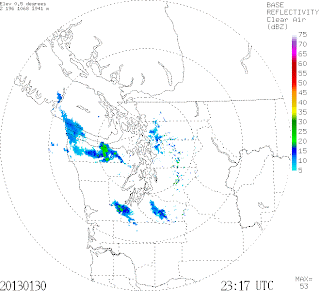 |
| Radar at 3:17 PM |
How could that be?
And consider that the origin of the light rain was very different from nearly all of the rain we get here during the winter.
Most rain in the Northwest starts in clouds as ice crystals aloft, often in an environment that also contains supercooled water (water below freezing, but still liquid). Precipitation develops through the cold-cloud process in which ice crystals collide and grow (aggregation) into snowflakes or ice assemblages, or collect supercooled water that freezes on to the crystal. As the ice crystals get larger and heavier they fall faster and collect more supercooled droplets and ice crystals. If the temperatures at low levels are cold we get snow, if warm, the ice crystals melt and we get rain.
 Since the precipitation falls from high up and the precipitation particles are fairly large, they show up well on radar.
But today we got some precipitation, the drizzle, from an entirely different process: the warm cloud process. In this process, clouds that are entirely above freezing can produce rain. Shallow warm clouds produce very light rain with small droplets: drizzle.
Imagine a shallow warm cloud made up of many, many small cloud droplets. Some droplets are bigger than others and fall a bit faster. They collect some of the droplets below them and get bigger and thus fall even faster. Thus, they get bigger and fall faster still, eventually leaving the cloud and falling as drizzle.

Today, the atmosphere was above freezing and saturated at low levels; here are the observations of temperature and dewpoint at Salem, Oregon up to about 7000 ft this morning at 4 AM. The X axis is temperature (degrees C) and the Y axis is height in pressure. The rest of the lines you don't want to know about! When temperature (right most line) and dew point (the other line) are the same, the air is saturated (relative humidity of 100%). You can see that the air was saturated and above freezing up to about 850 hPa (that is a pressure)---about 1500 meters or 5000 ft.
 So why did the radar have trouble seeing the drizzle? Two reasons. One is that very small droplets don't show up well on radar. Another is that the radar beam was already quite high when it got to Seattle (about 2000 ft), so it was above the largest drizzle drops, which are found lower in the shallow cloud.
Although warm rain is not rare in the Northwest it produces only a few percent of the precipitation. So enjoy it...I am sure a dermatologist would tell you it is good for your skin. And it tends to keep pesky Californians away.
Hiç yorum yok:
Yorum Gönder