But what has not been discussed in depth is the extraordinary transformation that will occur as Sandy makes landfall and moves inland....from a tropical to an extratropical storm, the first with a warm core and the latter with a cold core. I will talk about that here.
Right now Hurricane Sandy is almost exactly one day from landfall on New Jersey. It possesses sustained winds of 75 mph and a central pressure of 950 hPa, and is very large storm and will expand even more. Here is a recent infrared image, showing the band of moisture feeding into the center of the storm.

As I have mentioned before, hurricanes and tropical storms derive their energy from the warmth and moisture of warm oceans, and Sandy is no exception. Such tropical storms are warm-core systems, with the warmest air in their centers. In general, tropical storms are not found in regions with large horizontal changes in temperature.
Recently, there has been a substantial warm anomaly of the sea surface temperature (SST) of the western Atlantic (SST much warmer than normal), which helps tropical systems like Sandy move northward and stay strong longer than normal. Here is a recent map showing the SST anomaly: much warmer than normal along the path of Sandy, by over 1.5C! So a very attractive welcome mat had been laid for tropical storms over the western Atlantic.

Now midlatitude or extratropical storms get their energy not from warm oceans, but rather horizontal temperature changes---generally warmer to the south, cooler to the north. It turns out that the temperature changes on our planet are concentrated in the midlatitudes...and this temperature gradient fuels nearly all of the storms we experience in the winter. Midlatitude storms tend to be cold-core, with the coolest temperatures in their center.
Sometimes a tropical storm moves northward and undergoes an amazing transformation, from a warm core tropical system to a cold-core extratropical system, and switches its energy supply from the warmth and moisture of a tropical ocean to the temperature gradients of the midlatitudes. This is called Extratropical Transition (ET) in the business.
Sandy is about to go through the transformation.
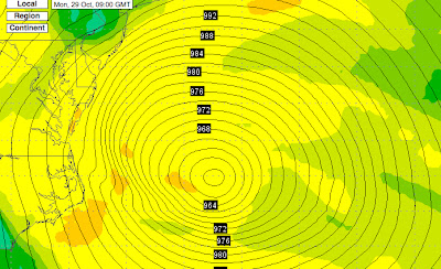
Let me show you. The figures below show you the temperatures and pressure pattern (actually heights of the 850 hPa pressure surface) at around 5000 ft above sea level for three times (Monday morning, Monday evening, and Tuesday morning--Seattle Time). At the initial time there is warm air at the center of the storm (the dark orange color). Fairly symmetric structure (which is typical of tropical systems).

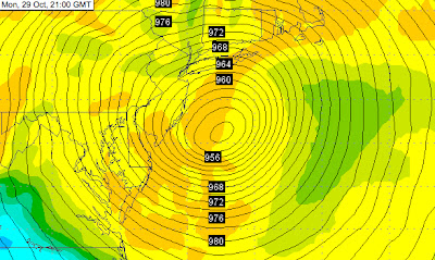
By tomorrow evening, just as the storm is making landfall, the warm core is fading, and temperature structure is becoming much more asymmetric.
 By Tuesday morning, the transformation is complete....cold air has reached the center of the storm and the warmest air is found far to the east of the center
Many tropical storms weaken when they go through this transition, but for a small subset the opposite occurs. The two energy sources work synergistically for a while, resulting in an strengthening and expanding system....such is the forecast fate of Sandy.
In fact, during this transition stage, Sandy will continue to intensity until it makes landfall. Here is the latest forecast from the NWS NAM model:
956 hPa low center at 2 AM Monday morning (PDT)
12 hours later 948 hPa pressure (2 PM Seattle Time).
My next blog will take a look at the scorecard for this storm....and return to talking about Northwest weather. And there is a lot to talk about, including an atmospheric river situation setting up and 5-10 inches forecast over the next 72 hr over NW mountains.


