To contact us Click
HERE
The National Weather Service has special weather statement out right now about the potential for snow over the western Washington lowlands and some of the TV stations have already started the drumbeat. As I will describe below, MOST of you will not see any snow accumulations, but some places (like western Kitsap County and Mason County, southwest WA) might get substantial accumulations. And lets not forget eastern Washington and the mountains, both of which should enjoy snow on Christmas Day.
 |
| Snow plow near Silverdale. Courtesy of Kitsap Sun. |
We are close enough to the event now that I have some confidence in the general picture of what will happen...but snow forecasts are always hard ones. Let me explain the meteorological situation and why Kitsap/Mason county are often snowy when the rest of the lowlands are wet.
The first thing to keep in mind is that the current temperatures are marginal for lowland snow. We really don't have very cold air over us, with the snow level at 1500-2000 ft. The snow level will fall a bit during the next day (by about 500 ft). Plenty cold for snow in the mountains and eastern Washington, but not for the west side.
After a relatively dry Monday, a fairly strong weather system will approach us. As illustrated by the forecast map at the surface for 7 AM on December 25th, a warm front will approach that morning. The solid lines are pressure, the colors are temperature (white, blue and purple are colder), and surface wind barbs are shown as well (click on image to blow it up). You will notice modestly cooler air over western Washington. The front will be accompanied by precipitation and moderate to strong southeasterly flow.

Strong southeasterly flow will be forced to rise up over the Olympic Mountains--in fact the lift starts tens of kilometers upwind of the Olympics. Thus, there will be heavier precipitation over Mason and Kitsap counties.
Here are the winds, temperatures, and pressures at roughly 5000 ft at 7AM on Tuesday. You can see the strong southeasterly flow and the cooling occurring over and immediately upstream of the Olympics. The central and eastern Puget Sound are a bit in the rainshadow of the Cascades (the southeasterly flow sinks on the western slopes of the Cascades and sinking air kills precipitation).

In marginal situations, places with less precipitation (like Seattle in this case) will be mainly rain (perhaps a few wet snow flakes mixed in on the hills), but areas with heavier precipitation rapidly turn to snow as melting of snow falling from aloft progressively cools the air air, pushing the snow level down to the surface. (heavier winter precipitation around here virtually always starts as snow aloft).
Let me show you the details! We can take the model forecasts and plot the wind, dew point (blue line), and temperature (red line) with height. Here is such a plot at Shelton, WA (Mason County, upstream of the Olympics) at 7 AM on the 25th. The x axis is temperature and the y axis is height in pressure (850 is about 5000 ft). You can see the southeasterly winds at low levels and the temperature is almost exactly 0C (32F) in the lower atmosphere. Why 0C? Because snow is melting in that entire layer! And the air is saturated (red and blue lines are on top of each other). A Kitsap classic.

But what about Seattle? Here is the same type of plot at the same time. The air is saturated (temperature and red lines are not on top of each other) and the air temperature is above freezing for a few thousand feet above the surface. Rain and disappointed kids.

Lets look st the 24-h snow maps for periods ending 4 PM on Tuesday and Wednesday. You can see the Kitsap and Mason county snows, and in fact it extend to Grays Harbor County as well. Portions of SW Washington may see some light snow, as the higher suburbs east of Seattle (e.g., Somerset neighborhood in Bellevue, Issaquah Highlands).

The next day, with warmer air, the snow is over over the west, but large parts of easterly Washington, including around Spokane and Wenatchee should be whitened up.

Here is the predicted snow for the next 72 hr. The Cascades will get plenty, particularly over the southern sections (e.g., Crystal, Mt. Hood!).

There are some uncertainties with this forecast (e.g., heavier precipitation more snow) and it would not shock me if Portland received a significant dusting. But I would be surprised if the general picture shown above is not correct. Temperatures are warming during the day, so if Seattle had a little wet snow during the initial stages of the event, it would turn to rain in a few hours.
Sobering fact: less than 10% of Christmas days are white in Seattle...
 They called their collection of log buildings, Fort Clatsop, and remained there until late March 1806 (see artist rendering).
 Unfortunately, they learned rapidly that they had picked one of wettest, dampest lowland places in North America, with plenty of wind to make things even more unpleasant They were miserable, as their comments on December 16, 1805 made clear:
  Of the 106 days the Corps of Discovery spent on the coast only twelve were free of rain and only six were sunny. I suspect they knew they had picked a very wet location, but wanted to be near the ocean where they would have a chance to interact with a passing ship. Perhaps they hoped for a ride to Hawaii.

 The purple colors are the heaviest snow on the map, virtually all of it over the mountains of the Pacific Northwest and southern B.C. Yes, I have to give credit to our neighbors to the north (but that is a short drive for us anyway).


 To show you this, here are the snow forecasts for the next two 72 h periods from the UW WRF model forecasts. For the next few days the Sierra and Siskiyou Mts. will get hammered with many feet of snow (yards in some places). We will slowly enhance our snowpack and BC/norther Rockies will get substantial amounts.
 For the second 72 hour period the snow accumulation is more evenly distributed up and down the coast, with over a foot of snow enjoyed by all. Eastern Washington and Oregon get plenty.
 All and all, a nice Holiday gift for those who enjoy winter recreation, and the amounts should not be heavy enough to mess up the roads.


 Do we have a chance of any records? The greatest annual rainfall at Sea-Tac was 55.14 inches in 1950. There is little chance we can reach that in a few days. Only three years (including 1950) got above fifty inches...there is a good chance we will get close to that level. In any case, we will "enjoy" living in one of the top 10 wettest years since 1948.
  The European Center Model has very little precipitation over the lowlands during the next week, and even the U.S. GFS model takes most of it to the north and south of us. This weekend looks fine, with only a few showers around. No serious weather.

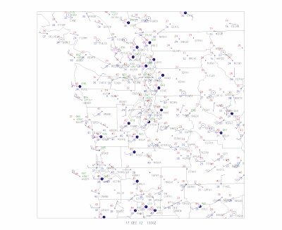 The maximum winds (gusts) for the 24 h ending 5 AM for Washington and Oregon are shown below. The Oregon coast got hammered with lots of places getting 50-60 mph winds, some more. Some 40-50 mph gusts in the Willamette valley.
 For Washington, 60 mph+ along the coast, with 40-60 mph in the Strait. 40-50 mph gusts in southern Puget Sound, with higher winds (up to around 60 mph) in the southern Sound.
 The biggest storm of the season so far (and I haven't even talked about snow in the mountains), but typical of the strongest storm we get each year.