28 Kasım 2012 Çarşamba

Hurricane Sandy's Transformation

To contact us Click HERE
A lot has been said of the severe damage that may accompany Hurricane Sandy---10-20 inches of precipitation west and southwest of the storm, coastal wind gusts exceeding 80 mph, severe damage to barrier beaches, flooding over western L.I. sound and other vulnerable locations.  The threat is great and imminent.

But what has not been discussed in depth is the extraordinary transformation that will occur as Sandy makes landfall and moves inland....from a tropical to an extratropical storm, the first with a warm core and the latter with a cold core.  I will talk about that here.

Right now Hurricane Sandy is almost exactly one day from landfall on New Jersey.  It possesses sustained winds of 75 mph and a central pressure of 950 hPa, and is very large storm and will expand even more.  Here is a recent infrared image, showing the band of moisture feeding into the center of the storm.


As I have mentioned before, hurricanes and tropical storms derive their energy from the warmth and moisture of warm oceans, and Sandy is no exception.  Such tropical storms are warm-core systems, with the warmest air in their centers.  In general, tropical storms are not found in regions with large horizontal changes in temperature.

 Recently, there has been a substantial warm anomaly of the sea surface temperature (SST) of the western Atlantic (SST much warmer than normal), which helps tropical systems like Sandy move northward and stay strong longer than normal.  Here is a recent map showing the SST anomaly:  much warmer than normal along the path of Sandy, by over 1.5C!  So a very attractive welcome mat had been laid for tropical storms over the western Atlantic.


Now midlatitude or extratropical storms get their energy not from warm oceans, but rather horizontal temperature changes---generally warmer to the south, cooler to the north.  It turns out that the temperature changes on our planet are concentrated in the midlatitudes...and this temperature gradient fuels nearly all of the storms we experience in the winter.  Midlatitude storms tend to be cold-core, with the coolest temperatures in their center.

Sometimes a tropical storm moves northward and undergoes an amazing transformation, from a warm core tropical system to a cold-core extratropical system, and switches its energy supply from the warmth and moisture of a tropical ocean to the temperature gradients of the midlatitudes.  This is called Extratropical Transition (ET) in the business.

Sandy is about to go through the transformation.

Let me show you.  The figures below show you the temperatures and pressure pattern (actually heights of the 850 hPa pressure surface) at around 5000 ft above sea level for three times (Monday morning, Monday evening, and Tuesday morning--Seattle Time).  At the initial time there is warm air at the center of the storm (the dark orange color).  Fairly symmetric structure (which is typical of tropical systems).


By tomorrow evening, just as the storm is making landfall,  the warm core is fading, and temperature structure is becoming much more asymmetric.

 By Tuesday morning, the transformation is complete....cold air has reached the center of the storm and the warmest air is found far to the east of the center


Many tropical storms weaken when they go through this transition, but for a small subset the opposite occurs.   The two energy sources work synergistically for a while, resulting in an strengthening and expanding system....such is the forecast fate of Sandy.

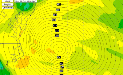
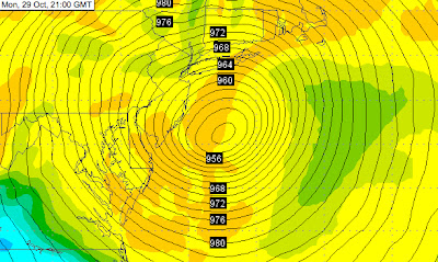
In fact, during this transition stage, Sandy will continue to intensity until it makes landfall.  Here is the latest forecast from the NWS NAM model:

956 hPa low center at 2 AM Monday morning (PDT)

12 hours later 948 hPa pressure (2 PM Seattle Time).

My next blog will take a look at the scorecard for this storm....and return to talking about Northwest weather.  And there is a lot to talk about, including an atmospheric river situation setting up and 5-10 inches forecast over the next 72 hr over NW mountains.


Strong Easterly Flow and the Graveyard of the Pacific

To contact us Click HERE
During the day the difference in pressure across the Cascades has increased as pressure has progressively fallen over the Pacific.   Right now the difference is around 7 hPa and rising, and such an offshore-directed pressure gradient is associated with increasingly easterly winds.

To illustrate, take a look at the sea level pressure forecast for tomorrow (Wednesday) at 10 AM.  An amazing large and intense low pressure area over the Pacific.  In fact, it appears to cover virtually the entire NE Pacific!
This offshore pressure gradient will get an added boast as a weak low pressure disturbance, embedded in this giant low rotates around near us.  There are several places that will get a good blow from this:  offshore over the eastern Pacific, along the western WA foothills (hello Enumclaw, Black Diamond, and North Bend), and along the western portions of the Strait of Juan de Fuca.  And later in the event NW Washington get strong winds.  Lets look at the last WRF surface sustained (not gust) winds for the next day.  First, 4 AM tomorrow (Wed).  20 kt sustained in the foothills (some folks will get gust to 40), and accelerating winds in the Strait, with sustained 25+ kt near Tatoosh Island.

 By 4 PM tomorrow, 30+ kt over the western Strait and similar winds northeast of the Olympics.  Those poor, sunburned folks in Sequim will get now be getting some wind burns as well.  Too windy for golf.

The western Strait can be very windy during such offshore flow, with air accelerating towards the west.  Strong winds, lots of rocks, and often clouds/fog make this region very dangerous for marine traffic, and, in fact, there have been numerous shipwrecks there, giving it the appellation of "Graveyard of the Pacific." During the days of sail (1830-1925) there were 137 major shipwrecks in the immediate vicinity of the entrance to the Strait. A major and tragic example is the 1906 shipwreck of the Valencia, with the loss of nearly 150 lives (see graphic).

The Valencia
The National Weather Service has a buoy in the middle of the western entrance to the Strait (46087)...here are the recent wind and pressure observations there.  Pressure is falling quickly and wind have increased to about 25 kt...and will increase further tonight.


Rain returns tomorrow afternoon, but with this large low over the NE Pacific, most of the flow will go south of us into southern Oregon and northern CA.  Here is the forecast precipitation for the 72 hr ending Saturday at 4 AM.  Huge amounts over northern CA.

Snow?   We will have relatively warm, southwesterly flow so Snoqualmie is out of luck.  Very marginal for Stevens.  Want snow?  You will have to go high...Baker, Crystal, and Whistler.


To contact us Click HERE
Update 11-28-2012
Forecast models bring a zonal flow, mainly from the west over the next 2 weeks. With this pattern above normal temperatures and precipitation. Thus higher snow levels in the mountains at times. Snow levels bounce around from 4000 to 6000 feet. The map below is average position of at the 500 mb level (18,000 feet).

For custom forecast anywhere in the world or if you need an expert witness in a legal weather related matter contact usClick here For our weather services or call toll free for information 877-969-4786. 

27 Kasım 2012 Salı

KUOW Hike of the Week- Slippery Creek

To contact us Click HERE
Updated 11-27-2012
Slippery Creek off of Highway 410 and usually at this time of the year you will need snowshoes but for this Tuesday and this Wednesday there is only 1 to 2 inches of snow at 4000 feet so no snowshoes needed. On clear day great views Mt. Rainier.
Photo below view of Mt. Rainier @photo Dennis Long

Check out Green Trails Maps for directions. The map for this hike is 238. Click here for complete list of maps. 
Photo below is Slippery Creek
Photo below this is a road walk
Photo below- not much snow at 4000 feet. No snowshoes needed now
Photo below  taken last year in November the amount of snow normally on ground @ photo Dennis Long
Driving Directions: From Enumclaw drive on State Highway 410 east and just before you get to the small town of Greenwater turn left on logging road FS 7125. This is just past MP 42. If you reach the town you have gone too far. Follow logging road FS 7125 then bear left which go about 1.5 miles and park at gate.Trail Directions: Follow road to point at about 3900 feet which is 1800 foot gain and 4 miles one way. See our track below.Always bring map-compass-GPS as these directions are the best estimates.
Click here To get permit that you need to access this area . 
Click here For our route. 


Hurricane Sandy's Transformation

To contact us Click HERE
A lot has been said of the severe damage that may accompany Hurricane Sandy---10-20 inches of precipitation west and southwest of the storm, coastal wind gusts exceeding 80 mph, severe damage to barrier beaches, flooding over western L.I. sound and other vulnerable locations.  The threat is great and imminent.

But what has not been discussed in depth is the extraordinary transformation that will occur as Sandy makes landfall and moves inland....from a tropical to an extratropical storm, the first with a warm core and the latter with a cold core.  I will talk about that here.

Right now Hurricane Sandy is almost exactly one day from landfall on New Jersey.  It possesses sustained winds of 75 mph and a central pressure of 950 hPa, and is very large storm and will expand even more.  Here is a recent infrared image, showing the band of moisture feeding into the center of the storm.


As I have mentioned before, hurricanes and tropical storms derive their energy from the warmth and moisture of warm oceans, and Sandy is no exception.  Such tropical storms are warm-core systems, with the warmest air in their centers.  In general, tropical storms are not found in regions with large horizontal changes in temperature.

 Recently, there has been a substantial warm anomaly of the sea surface temperature (SST) of the western Atlantic (SST much warmer than normal), which helps tropical systems like Sandy move northward and stay strong longer than normal.  Here is a recent map showing the SST anomaly:  much warmer than normal along the path of Sandy, by over 1.5C!  So a very attractive welcome mat had been laid for tropical storms over the western Atlantic.


Now midlatitude or extratropical storms get their energy not from warm oceans, but rather horizontal temperature changes---generally warmer to the south, cooler to the north.  It turns out that the temperature changes on our planet are concentrated in the midlatitudes...and this temperature gradient fuels nearly all of the storms we experience in the winter.  Midlatitude storms tend to be cold-core, with the coolest temperatures in their center.

Sometimes a tropical storm moves northward and undergoes an amazing transformation, from a warm core tropical system to a cold-core extratropical system, and switches its energy supply from the warmth and moisture of a tropical ocean to the temperature gradients of the midlatitudes.  This is called Extratropical Transition (ET) in the business.

Sandy is about to go through the transformation.

Let me show you.  The figures below show you the temperatures and pressure pattern (actually heights of the 850 hPa pressure surface) at around 5000 ft above sea level for three times (Monday morning, Monday evening, and Tuesday morning--Seattle Time).  At the initial time there is warm air at the center of the storm (the dark orange color).  Fairly symmetric structure (which is typical of tropical systems).


By tomorrow evening, just as the storm is making landfall,  the warm core is fading, and temperature structure is becoming much more asymmetric.

 By Tuesday morning, the transformation is complete....cold air has reached the center of the storm and the warmest air is found far to the east of the center


Many tropical storms weaken when they go through this transition, but for a small subset the opposite occurs.   The two energy sources work synergistically for a while, resulting in an strengthening and expanding system....such is the forecast fate of Sandy.

In fact, during this transition stage, Sandy will continue to intensity until it makes landfall.  Here is the latest forecast from the NWS NAM model:

956 hPa low center at 2 AM Monday morning (PDT)


12 hours later 948 hPa pressure (2 PM Seattle Time).


My next blog will take a look at the scorecard for this storm....and return to talking about Northwest weather.  And there is a lot to talk about, including an atmospheric river situation setting up and 5-10 inches forecast over the next 72 hr over NW mountains.


26 Kasım 2012 Pazartesi

Hurricane Sandy's Transformation

To contact us Click HERE
A lot has been said of the severe damage that may accompany Hurricane Sandy---10-20 inches of precipitation west and southwest of the storm, coastal wind gusts exceeding 80 mph, severe damage to barrier beaches, flooding over western L.I. sound and other vulnerable locations.  The threat is great and imminent.

But what has not been discussed in depth is the extraordinary transformation that will occur as Sandy makes landfall and moves inland....from a tropical to an extratropical storm, the first with a warm core and the latter with a cold core.  I will talk about that here.

Right now Hurricane Sandy is almost exactly one day from landfall on New Jersey.  It possesses sustained winds of 75 mph and a central pressure of 950 hPa, and is very large storm and will expand even more.  Here is a recent infrared image, showing the band of moisture feeding into the center of the storm.


As I have mentioned before, hurricanes and tropical storms derive their energy from the warmth and moisture of warm oceans, and Sandy is no exception.  Such tropical storms are warm-core systems, with the warmest air in their centers.  In general, tropical storms are not found in regions with large horizontal changes in temperature.

 Recently, there has been a substantial warm anomaly of the sea surface temperature (SST) of the western Atlantic (SST much warmer than normal), which helps tropical systems like Sandy move northward and stay strong longer than normal.  Here is a recent map showing the SST anomaly:  much warmer than normal along the path of Sandy, by over 1.5C!  So a very attractive welcome mat had been laid for tropical storms over the western Atlantic.


Now midlatitude or extratropical storms get their energy not from warm oceans, but rather horizontal temperature changes---generally warmer to the south, cooler to the north.  It turns out that the temperature changes on our planet are concentrated in the midlatitudes...and this temperature gradient fuels nearly all of the storms we experience in the winter.  Midlatitude storms tend to be cold-core, with the coolest temperatures in their center.

Sometimes a tropical storm moves northward and undergoes an amazing transformation, from a warm core tropical system to a cold-core extratropical system, and switches its energy supply from the warmth and moisture of a tropical ocean to the temperature gradients of the midlatitudes.  This is called Extratropical Transition (ET) in the business.

Sandy is about to go through the transformation.

Let me show you.  The figures below show you the temperatures and pressure pattern (actually heights of the 850 hPa pressure surface) at around 5000 ft above sea level for three times (Monday morning, Monday evening, and Tuesday morning--Seattle Time).  At the initial time there is warm air at the center of the storm (the dark orange color).  Fairly symmetric structure (which is typical of tropical systems).


By tomorrow evening, just as the storm is making landfall,  the warm core is fading, and temperature structure is becoming much more asymmetric.

 By Tuesday morning, the transformation is complete....cold air has reached the center of the storm and the warmest air is found far to the east of the center


Many tropical storms weaken when they go through this transition, but for a small subset the opposite occurs.   The two energy sources work synergistically for a while, resulting in an strengthening and expanding system....such is the forecast fate of Sandy.

In fact, during this transition stage, Sandy will continue to intensity until it makes landfall.  Here is the latest forecast from the NWS NAM model:

956 hPa low center at 2 AM Monday morning (PDT)


12 hours later 948 hPa pressure (2 PM Seattle Time).


My next blog will take a look at the scorecard for this storm....and return to talking about Northwest weather.  And there is a lot to talk about, including an atmospheric river situation setting up and 5-10 inches forecast over the next 72 hr over NW mountains.


Triple Rainbow

To contact us Click HERE
One of the reasons I keep this blog going is the wonderful feedback from you, the readers, including the images some send me.  Yesterday, another one came in:  a very rare triple rainbow.

Here is the picture provided by Anna Jensen-Clem, taken around 3:15 PM Saturday in Kenmore just south of the intersection of 68th Ave NE and Bothell Way.


 You start by noticing two parallel bows than curve upwards to to the right.   These we see all the time.  The brighter one (to the right) is the primary bow and the second one (to the left) is the weaker secondary bow.  If you are very observant you will notice that the colors are reversed on them.

But there is another bow, considerably dimmer, that extends almost vertically from the primary bow, this is the unusual one.   And a nice example of something I have read about, but never seen personally, a reflection bow.  But what is it reflecting off?   Let's figure this out!

First, to get primary and secondary bows you need sun, rain, and the properly geometry.

Looking at the Camano Island radar image at 3:16 PM, we can see the shower in question over the northern portion of Lake Washington.  Got rain!


And the satellite image at 3:15 PM indicated it was mainly clear to the south.  Got sun.


 Now to get the normal primary and secondary rainbows you need the sun behind you and the rain in front of you.  As shown in the figure below, in the primary rainbow light is reflected once off the back of a raindrop and for the secondary raindrop there are two reflections.  That produces slightly different angle of the colors.  The colors are produced by the refraction of light entering and leaving the droplet, with different wavelengths of light (blue, red, yellow, etc.) being bent differently. The center of the rainbow, the center of the rainbow arc, is on the opposite side of the sky from the sun (the antisolar point)


So what about that rare extra bow photographed by Ms. Jensen-Clem?

The sun causing it appeared from the same direction as the primary bow but the bow is higher in the sky, which implies the sun would be coming from a  lesser angle.  This is a reflection bow, in which the sun's light is reflected off a water surface, thus coming from a lesser angle, and then producing a rainbow.  To get the geometry right, you need to have the sun relatively low (something true at 3:15 PM in late November).   Here is a diagram that shows what is going on.  The yellow represents the rays coming directly from the sun and the red the reflected rays. 

The difference in angle causes the rainbow to be shifted up. (see figure)


The water obviously needs to be behind the observer.  So where was the water for the Bothell bow?  Here is a map of the region.  The photo was taken a bit south of "A"--the intersection of 68th Ave. and Bothell Way.   Lake Washington provided the reflection surface..the geometry is just right.

It all fits...

 Finally, in a future blog I will tell you what many really want to know, particularly with holiday shopping season upon us:  how to find the gold at the end of the rainbow.  You also have to master dealing with Leprechauns, something we teach in our graduate classes in the department.