To contact us Click
HERE
Friday AM Update: Weather-Related Fire Threat this Weekend
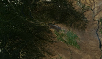
Once the new runs come this morning, I will talk about the threat of lightning and strong winds returning to Kittitas County (Cle-Elum to Ellensburg). Talked about it on KPLU this morning (9AM on air or on KPLU.ORG after 9:30 AM)As our hearts go out to the people who have lost their homes, businesses, and animals in the Taylor Bridge fire near Cle Elum and Thorp, the natural question for west-side residents is: could it happen here? Could a major fire strike the region west of the Cascade crest?
The short answer is yes...it not only can happen but HAS happened, particularly along the western slopes of the Cascades.
The reality of this is brought home by the release today by the National Weather Service of a RED FLAG Warning for some parts of western Washington and Oregon (see graphic). This is exceedingly rare.

Perhaps the most well known west-side fire is the famous
Yacolt Burn of Sept. 11-13, 1902, the largest forest fire in Washington state history, which burned 238,920 acres -- more than 370 square miles -- and killed 38 people in Clark, Cowlitz, and Skamania counties.
 |
| Results of the Yacolt Burn |
Fanned by strong, dry easterly winds, the fire traveled 30 miles in 36 hours. A half-inch of ash covered Portland and the smoke was so thick that street lights went on mid-day in Seattle. Here is a (poor) map the the Yacolt Burn area.

Then there was the great
Tillamook Burn...a series of four fires in the old-growth forecasts along the northern Oregon coast range that destroyed a total of 355,000 acres during the period of 1933-1951.
 |
| Tillamook Burn |
And in 1951 there was the famous
Forks Fire that burned an area approximately 20 miles long and 2-1/2 miles wide, covering 32,668 acres. Fanned by strong easterly winds, the fire moved 18 miles in eight hours. You can see a repeated issue here for western Washington/Oregon fires...they tend to be associated with strong easterly winds and can move fast...real fast. And most follow periods of both hot weather and drought.
Recently, I read a paper by Hemstrom and Franklin (Quaternary Journal, 1982) in which they talked about the role of big fires at Mount Rainier Park. Looking a tree rings and other evidence, they determined that natural big fires cause trees to be replaced roughly every 430 years in the park. The largest and oldest big fire occurred around 1230 AD and interestingly some of the oldest stands of trees in the the park date to that fire. A place with very old trees is one of my favorite Rainier locations: the Grove of the Patriarchs near Ohanepecosh, which were protected by surrounding water. Some of the trees there are over a 1,000 years old.
 |
| Surrounding rivers helped protect the Grove of the Patriarch from fire. |
Fire has become a more serious threat, and global warming, although contributing, may not be the biggest issue. We have poorly managed our forests, particularly on the drier, eastern slopes--stopping natural fires and letting the forest grow too dense. And people have moved their homes up into the forest zone, in locations that are naturally and regularly visited by fire. Fire is an important part of forest and grassland ecosystems in many locations. We should not forget that. And we should not forget that although we live in an area with very wet winters, our summers are some of the driest in the country. There has been little rain during the past three weeks...and that is not unusual at all.
For those of you like probcast, it can be found at:
http://probcast.washington.edu/
 Green Trails Maps- One of the 10 essentials
 Photo below is of Spray Falls
 Photo below are the flowers in Spray Park
 Photo below are Avalanche Lilies in the Park
 Photo below is of Hessong Rock from Spray Park

 Issued Wednesday 8-22-2012

 Photo below is of momma goat and baby- keep distance
 Photo below is of Frozen Lake
 Photo below is sun is starting to set
 Driving Directions: From Enumclaw, drive east 43 miles on State Route 410 to the Mount Rainier National Park White River Entrance. Go up to the Sunrise Road and and park at the large parking lot and visitor center.
 If you encounter a goat here are some suggestionshttp:// http://www.wta.org/signpost/mountain-goat-basics-give-the-goat-the-trail-1 >

 Photo below in hiking from Bullion Basin now on Crest trail @Sykes
 Photo below is lazy hikers or hikers resting @Long
 Photo below is Henskin Lake @Sykes
 Driving Directions: From Enumclaw drive east on State Route 410 about 34 miles and turn left (east) onto Crystal Mountain Road (Forest Road 7190) leading to the Crystal Mountain Ski Area. Drive about 5 miles to the end of the road and trailhead is on the left of the upper lot. You can drive a little closer to trail -see map but this is the easiest way.


 The winds at the Ellensburg Airport came up yesterday and are still quite strong:


 Beautiful thermal troughs and a big warm up for the west side. Low pressure moves to the west side of the mountains! As a result, the westerly winds will end overnight, being replaced by weak easterlies. Hopefully, that will enable the firefighters to get this explosive blaze under control.