Smoke has filled much of the Northwest today, and we didn''t need any Asian smoke to assist. The latest MODIS satellite image shows a huge quantity of smoke over California and southern Oregon from local wildfires, and, of course, there is the rapidly growing Taylor Bridge fire between Yakima and Ellensburg (see below). This fire grew explosively during the past 24-h and now encompasses more than 25,000 acres. A big part of the problem has been the winds...which have gusted to 40-50 mph in places.

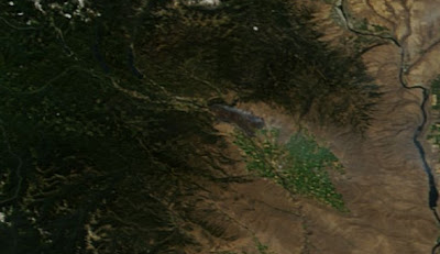
Here is close up of the Cle Elum/Ellensburg area...you can see the smoke...although it is a bit subtle.
Why did it explode so quickly and why am I hopeful that the driving winds will eventually decline?
The Cle Elum to Ellensburg area, as most of you know, is a very windy corridor during much of the warm season. It is downwind a major weakness in the Cascades that meteorologists often call the Stampede Gap. During a normal summer day, when high pressure dominates the eastern Pacific and lower pressure is inland, westerly winds can blow quite powerfully through the Stampede Gap into Cle Elum and down into Ellensburg. That is why there are so many wind turbines there. But the problem is that IF a fire gets started that winds can cause them to spread rapidly and explosively...and unfortunately that has happened. In some ways, this is one of the WORST places to have a fire because of the strong gap winds of the area.
Here is the pressure and winds of the past two days for around 5 PM. Classic westerly wind pattern.


Take a look at the surface (actually 30 ft) winds from the UW WRF model for 5 PM today. You can see the strong winds in the Stampede Gap and downstream.
 The winds at the Ellensburg Airport came up yesterday and are still quite strong:
 |
| Ellensburg Sustained Winds |
 |
| Ellensburg Gusts |
But I am hopeful the winds will weaken around the fire, giving the fire folks a chance to bring it under control. Why? Because of the upcoming western Washington heat wave! A thermal trough will move up the coast and will result in a weakening and then reversal of the pressure gradient. Here are the forecast maps for the next two days at 5 PM to show you what should happen:

 Beautiful thermal troughs and a big warm up for the west side. Low pressure moves to the west side of the mountains! As a result, the westerly winds will end overnight, being replaced by weak easterlies. Hopefully, that will enable the firefighters to get this explosive blaze under control.
Orcas Island Talk on August 29th
I will be giving a talk: Global Warming, Separating Truth from Hype at 5:30 PM on August 29th at the Orcas Center Madrona Room.


 Then there was the great Tillamook Burn...a series of four fires in the old-growth forecasts along the northern Oregon coast range that destroyed a total of 355,000 acres during the period of 1933-1951.

 The cool air will be mixed out and temperatures will soon surge into the upper 80s and low 90s away from the water. One last really hot day.

 The trouble is that a lot of these thunderstorms will be high-based, meaning there will be lightning, but limited rain reaching the surface. The threat of lightning-caused fires is substantial.
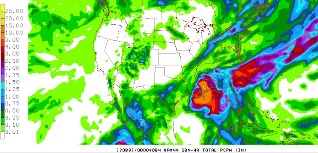
 Take a look at the precipitation forecast for the 24-h period ending 5 PM Sunday. If anything, these simulations tend to underplay the convective rain.


 So how can this be? No rain for a month and no drought? Because this is pretty much normal for around here...in fact, we are one of the driest places in the country from mid-July through mid-August.
 The sunny, warm conditions of late have done wonders for my tomatoes--quite a few red, ripe ones already.
 The pattern do not look favorable for convection of the Cascades and eastern Cascade slopes...which is good for the fire situation.
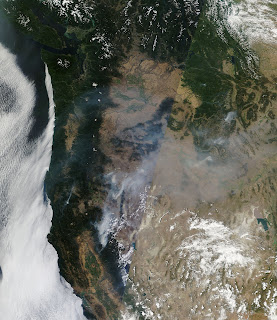
 We can take a closer look off the Oregon coast by viewing the SSTs forecast by the Oregon ROM ocean modeling system (I used the NANOOS web site to plot this). Lower to mid-50s along the coast while lower 60s are waiting 100 miles offshore.
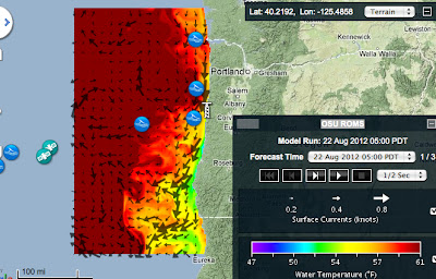

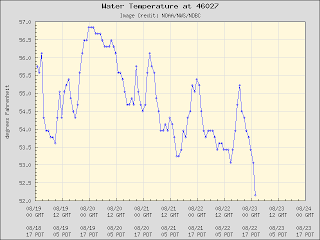 But head out to Buoy 46006 and temperatures in the in sultry mid to upper 60s.
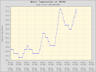


 Multiple such urbanization/development issues at locations around the world, and it is clear that it can obscure the true background temperature change signal that we are looking for. Organizations, such as the National Climatic Data Center, have tried to develop algorithms to spotlight or remove such problems, but there success so far is mixed. Satellite observations of temperature above the surface are a bit less problematic, although they have their own issues (like calibration of replacement satellites).

 The latest radar image from Miami shows bands of intense showers rotating around Isaac's center:


 Pretty impressive precipitation.