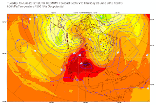
Forecast models continue the pattern of bringing troughs of low pressure that drop down from the Gulf of Alaska to cooler temperatures and precipitation at times. This pattern will continue at times and the map below (500 mb- 18,000 feet) indicates this as there is a trough of low pressure of the Washington coast on June 28. We see this pattern occurring on and off between now and June 28. However we will get a ridge of high pressure (like June 20 and June 21) that builds briefly for a warm and dry pattern. 
21 Haziran 2012 Perşembe
Extended weather forecast Cascades
To contact us Click HERE
Issued Wednesday June 20, 2012
Kaydol:
Kayıt Yorumları (Atom)
Hiç yorum yok:
Yorum Gönder