AND it was probably the most powerful non-tropical cyclone to strike the lower-48 states during the past century.
The Columbus Day Storm occurred on October 12, 1962, with the fiftieth anniversary this week.
I have thought a lot about this event, partially because one of my research areas has been intense Northwest storms and in part because I am giving a talk on Thursday at Kane Hall.
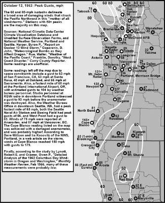
The winds during the storm were amazing (see graphic of peak gusts, courtesy Wolf Read). Over 145 mph at Cape Blanco, 138 mph at Newport, over 130 mph at Mt. Hebo, 160 mph at the Naselle radar site in SW Washington, 116 in Portland, and 100 mph in Renton (so those people who put down Renton keep this in mind!).
The central pressure of the Columbus Day Storm (CDS) dropped to approximately 955 hPa and was equivalent in pressure and winds to a category 3 hurricane (like Katrina as it struck New Orleans). I have little doubt that if the CDS hit today it would result in many billions, if not tens of billions, of dollars of damage. The Columbus Day Storm was FAR stronger than the "Perfect Storm" (Halloween 1991) of movie fame. I mean it wasn't even close.

Before the storm was over 46 people had died, 317 were hospitalized, and 15 billion board feet of timber, enough to build 300,000 homes, had fallen. Millions had lost power, with the twin high-tension power lines to Portland toppled like some children's Tinker Toys.
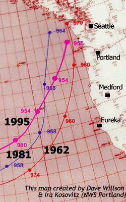
An interesting aspect of this storm was that is started as Typhoon Freda in the western Pacific. Moving northward, this storm weakened and transitioned into a midlatitude cyclone. In doing so, it switched energy sources from the warmth and moisture of the tropical Pacific to the differences in temperatures found in the midlatitudes (sort of a meteorological version of a hybrid car). Moving across the Pacific, it swung south into a large trough over the eastern Pacific and then moved northward along the West Coast, growing very rapidly (see graphic of the path over the eastern Pacific of that storm and a few other big ones).
Here is a surface analysis (by Lynott and Cramer 1966) when the storm was immediately off the Oregon coast around 3 PM on October 12th). Huge pressure gradients (differences) along the coast, which resulted in the amazing winds.
 Did they forecast this event skillfully? Alas, the answer is no. The weather prediction made on October 11th was for improving conditions and no storm. Only early on the 12th, when some ominous ship reports were received, did Weather Bureau forecasters realize that there was a serious storm approaching the region.
At my presentation on Thursday I will show a simulation that Rick Steed of my group made of this storm using a modern weather prediction system (WRF model). We still failed to get a good forecast and I think I know the reason: lack of enough data over the Pacific to initialize the model. But don't worry, today we have so much information over the oceans (satellite data, aircraft information, buoys) that I have little doubt we would get the forecast correct. In fact, my colleagues at the National Weather Service have not missed a major Northwest windstorm a day out since roughly 1990.
Hiç yorum yok:
Yorum Gönder