To contact us Click
HERE
During the past few weeks the stories have been incessant. One major highway after another has been closed for extended periods recently as hundreds of snow-encased trees have fallen over the roadways, including SR-2 across the central Cascades, the Mount Baker Highway, RT 6 and 101, on the Olympics Peninsula. Large deposits of snow weighted the trees down until they toppled over.
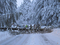 |
| Mount Baker Highway: WSDOT Photo |
A number of cars have been hit, nine people injured and tragically two were killed on December 21, just east of Leavenworth. The Mt. Baker ski area was inaccessible for days and folks had to go the long way around (I90, 97) to get to Leavenworth and vicinity.
 |
| Mount Baker Highway: WSDOT Photo |
 |
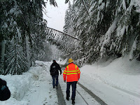
| SR-101 Closed |
 |
| SR-2 Trees Leaning Over: WSDOT Photo |
Long-time Washington Department of Transportation maintenance personnel say they have never seen a situation like this, with snow causing such extensive and long-lasting tree fall periods over state roadways. I have been around for a while and can't remember an analogous situation. The threat was so large that WSDOT began flying over the road with helicopters, in the hope of blowing off snow.
So were the trees falling? We have had periods of more snow, of more wind, of more rain. Periods that were colder. What is different this time?
Let's play detective!
 |
| When you have eliminated the impossible, whatever remains, however improbable, must be the truth....S. Holmes |
The last month has been a wet one over the region and the mountains have gotten large amounts of snow. But other years have had as much or more snow in the mountains (e.g., 98-99) without so many trees coming down.
So snowfall alone is not the answer.What about the locations and altitudes? The SR-2 tree falls occurred about 10 miles west of Leavenworth at an altitude of roughly 2400 ft (see mapP
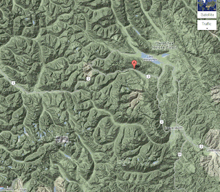
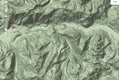
The Mount Baker Highway tree falls occurred east of Maple Falls (see map, east of red A). Elevation about 1400 ft.
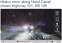
U.S. 101 on the Olympic Peninsula was closed between Shelton and Brinnon with trees downed not far from sea level. So the elevations varied.
I think there is an answer. There is something that all these elevations had in common during the period, something that I believe caused massive tree falls. So let me give you my hypothesis. Let's consider the facts, my dear Watson.
Fact 1: We know that the trees fell when they were weighted down with snow.
Fact 2: Snow is most "sticky" near and just below freezing (say mid-20s to freezing)
Fact 3: During really cold periods (our Arctic outbreaks) snow tends to be lighter, less sticky, and more easily blown off trees.
Fact 4: Major warm up periods (e.g., pineapple express atmospheric river periods) have very high freezing levels and rain at most elevations, resulting in melting and washing off snow from trees.
There WERE some unusual aspects of the past few weeks that allowed large amounts of snow to stick on trees until they fell over.Thinks about it. This month we did not have any major Arctic, cold-air, outbreaks. So no really cold, light snow that doesn't stick well. We have NOT had any pineapple expresses or warm up periods that would melt the snow at a wide range of elevations. In fact, recent temperatures in the mountains have been AMAZINGLY steady. Let me demonstrate this.
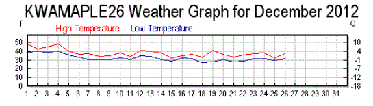
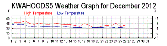
Take a look at the temperatures (red daily high, blue daily low) at the Winton weather station run by the WA DOT. Winton (MTWINT, roughly at 2000 ft MSL) is several miles north of Leavenworth on RT 2...not far from the tree falls. Or Nason Creek (a bit farther north at 2000 MSL as well).

 Only minor temperature variations
. Temps never got above 40F and only below 20F on the 18th and 19th. Most of the two weeks (Dec 7-21st) before the major tree falls on RT 2 had highs in the low 30s and lows in the mid 20s. Perfect temperatures to deposit snow on trees. And winds were generally light...and thus not blowing snow off the branches.
This is a very unusual situation.
What about the Mt. Baker Highway tree falls? Lets consider the Maple Falls station (a bit lower--670ft--than the section with the tree falls). AGAIN, amazingly constant temperatures in mid-December, with highs in the mid to upper 30s and lows around 30F. Go a little higher, to where the trees were falling, and temperatures were surely cooler..right in the range of maximum stickiness and deposition.
But you ask, what about the trees (less numbers) falling near the Hood Canal? Surely, it was much warmer there? The answer is no....that area can be unusually cool for the lowlands, as southeasterly flow banks cool air over that area. Consider Lake Cushman, which is close to sea level, and on the SE side of the Olympics, not far from 101. A number of day had highs in the lower to mid thirties, starting December 19th. And yes, temperatures were relatively constant.
So my hypothesis is that we had a wet, snowy period with consistently cool, but not super cold, temperatures in a range that promoted sticky snow. No major wind events to blow off snow. No pineapple express warming. It all game together in a very unusual way, causing massive snow loading on trees. Another contributor might be the mild temperatures that have left the ground unfrozen and thus less able to hold the trees in place. Perhaps one of you have an alternative theory...if so, I would like to hear it!
Certainly, not "elementary."

 They called their collection of log buildings, Fort Clatsop, and remained there until late March 1806 (see artist rendering).
 Unfortunately, they learned rapidly that they had picked one of wettest, dampest lowland places in North America, with plenty of wind to make things even more unpleasant They were miserable, as their comments on December 16, 1805 made clear:
  Of the 106 days the Corps of Discovery spent on the coast only twelve were free of rain and only six were sunny. I suspect they knew they had picked a very wet location, but wanted to be near the ocean where they would have a chance to interact with a passing ship. Perhaps they hoped for a ride to Hawaii.
 The Climate Prediction Center prediction for the next 6-10 days is drier than normal for most of the west:
 The origin of this boon is a major switch in circulation, with persistent ridging along the West Coast. Here are some sample upper level charts for Sunday and Tuesday:
 What a wonderful opportunity to clean leaves out of your gutters and rake up leaves in your sodden yards....or to enjoy an outdoor walk or bike ride.

 Here is forecast surface chart for 10 AM this morning. You can see the low (solid lines are pressure) off the southern WA coast, and the temperatures (at around 2500 ft, shown by shading) indicated the cold air over eastern Washington and cool air over the western WA lowlands.
 This is NOT going to be big snow event. Here is the model forecast from this morning, showing the 24-h total snowfall prediction over the region. Not more than about 1-2 inches in the most favored zones. Nothing over the Seattle Metro area (sorry, Jim Forman). Portland gets some white stuff.
 The purple colors are the heaviest snow on the map, virtually all of it over the mountains of the Pacific Northwest and southern B.C. Yes, I have to give credit to our neighbors to the north (but that is a short drive for us anyway).


 To show you this, here are the snow forecasts for the next two 72 h periods from the UW WRF model forecasts. For the next few days the Sierra and Siskiyou Mts. will get hammered with many feet of snow (yards in some places). We will slowly enhance our snowpack and BC/norther Rockies will get substantial amounts.
 For the second 72 hour period the snow accumulation is more evenly distributed up and down the coast, with over a foot of snow enjoyed by all. Eastern Washington and Oregon get plenty.
 All and all, a nice Holiday gift for those who enjoy winter recreation, and the amounts should not be heavy enough to mess up the roads.
 Strong southeasterly flow will be forced to rise up over the Olympic Mountains--in fact the lift starts tens of kilometers upwind of the Olympics. Thus, there will be heavier precipitation over Mason and Kitsap counties.
  In marginal situations, places with less precipitation (like Seattle in this case) will be mainly rain (perhaps a few wet snow flakes mixed in on the hills), but areas with heavier precipitation rapidly turn to snow as melting of snow falling from aloft progressively cools the air air, pushing the snow level down to the surface. (heavier winter precipitation around here virtually always starts as snow aloft).
 But what about Seattle? Here is the same type of plot at the same time. The air is saturated (temperature and red lines are not on top of each other) and the air temperature is above freezing for a few thousand feet above the surface. Rain and disappointed kids.
 The next day, with warmer air, the snow is over over the west, but large parts of easterly Washington, including around Spokane and Wenatchee should be whitened up.
 Here is the predicted snow for the next 72 hr. The Cascades will get plenty, particularly over the southern sections (e.g., Crystal, Mt. Hood!).


